Körzüt is located in the Muradiye Plain, about 9 km (5.6 mi) from the district center in Van Province. It was a strategic point, controlling the routes from Tushpa to the north and the agricultural lands of the plain.
History
- According to inscriptions (village of Uluşar), the city was founded by King Menua.
- The Menua stele in Karahan (8 km / 5 mi from Körzüt) mentions the gates of Haldi in the city of Arsuniu.
- Evidence suggests that Arsuniu and Körzüt are the same location.
- During the reigns of the Urartian kings Ishpuini and Menua, the kingdom expanded into remote territories, collecting goods and capturing prisoners, which were used in urban development.
Size and Structure of the Körzüt Fortress
Citadel: 4.9 hectares (12.1 acres); surrounding settlements: 4.8 hectares (11.9 acres).
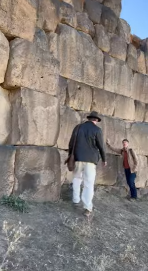
Surrounded by cliffs to the west, south, and northwest; to the northeast by walls 8 m (26 ft) high.
Walls: 4 m (13 ft) thick, built with square/rectangular basalt stones with curved exterior stones; brackets 5 m (16 ft) wide, 1 m (3.3 ft) deep, spaced 8 m (26 ft) apart.
Picture from this Matthew La Croix video youtube.com/shorts/QfPVYxvRtnM
Access and Buildings
- Main entrance: northeast, with the gate protected by 10 m (33 ft) long walls on both sides.
- Traces of buildings in the northwest and southwest parts of the citadel.
- Buildings with rectangular and square plans, mainly in the northwest.
Source: urartians.com.tr